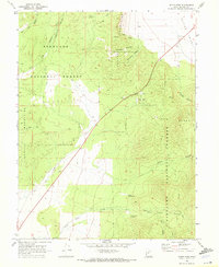
1969 Map of Scipio Pass
USGS Topo · Published 1972About this map
Scipio Pass serves as the focal point of this 1960s topographic survey, marking the strategic gap between the Canyon Mountains to the north and the Pavant Range to the south. This rugged landscape within the Fishlake National Forest is characterized by deep drainage systems like Eightmile Canyon and Wild Goose Canyon. The transition from the high peaks of the Church Mountains down into the Scipio Valley illustrates the classic Basin and Range geology of Millard County. Human footprints on this terrain are sparse but telling, represented by a network of Jeep Trails and Pack Trails that connect remote water sources such as Wild Goose Spring and Mud Spring. Infrastructure is limited to a few landmarks including a Radio Tower and Substation, highlighting the area's role as a transit corridor through central Utah.
Find a feature on this map
27 named features on this map. Tap any name to fly to it.
Don’t see what you’re looking for? This feature index may not catch every label — zoom into the map to look around manually.
Map Details
Editions of this 1969 Scipio Pass Map
This is the sole edition of this map. No revisions or reprints were ever made.
Other maps of this area

1885 · Sevier Desert
USGS Topo · 1:250,000

1951 · Oak City
USGS Topo · 1:62,500

1952 · Scipio North
USGS Topo · 1:62,500

1953 · Delta
USGS Topo · 1:250,000

1958 · Delta
USGS Topo · 1:250,000

1962 · Delta
USGS Topo · 1:250,000
1962 · Holden
USGS Topo · 1:24,000

1962 · Holden
USGS Topo · 1:62,500
1969 · Scipio Lake
USGS Topo · 1:24,000
1969 · Coffee Peak
USGS Topo · 1:24,000