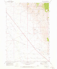
1969 Map of Scott Butte
USGS Topo · Published 1973About this map
Birch Creek Valley dominates this landscape in the late 1960s, serving as a geographic corridor between the high terrain of the Targhee National Forest and the industrial activity of the south. This area demonstrates a sharp contrast between natural resource management and atomic-era research, with the southern portion of the sheet occupied by the National Reactor Testing Station. The presence of the Reno Ditch and Birch Creek highlights the essential role of water engineering in this high-desert environment, while multiple canyons like Deadman Canyon and Peterson Canyon drain the eastern slopes toward the valley floor.
Find a feature on this map
21 named features on this map. Tap any name to fly to it.
Don’t see what you’re looking for? This feature index may not catch every label — zoom into the map to look around manually.
Map Details
Editions of this 1969 Scott Butte Map
This is the sole edition of this map. No revisions or reprints were ever made.
Other maps of this area

1955 · Dubois
USGS Topo · 1:250,000

1955 · Idaho Falls
USGS Topo · 1:250,000

1958 · Dubois
USGS Topo · 1:250,000

1958 · Idaho Falls
USGS Topo · 1:250,000

1969 · Shamrock Gulch
USGS Topo · 1:24,000

1969 · Circular Butte NW
USGS Topo · 1:24,000

1969 · Eightmile Canyon
USGS Topo · 1:24,000

1969 · Richard Butte
USGS Topo · 1:24,000

1969 · Tyler Peak
USGS Topo · 1:24,000

1969 · Copper Mtn
USGS Topo · 1:24,000