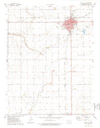
1976 Map of Scott City
USGS Topo · Published 1978About this map
Scott City serves as the busy hub of this Western Kansas landscape, where the intersection of the Atchison Topeka and Santa Fe and Missouri Pacific railroads dictated the town's grid and growth. The map illustrates a well-developed mid-century community featuring a courthouse, hospital, and various schools including St Joseph Sch. Beyond the residential streets, the geography is defined by the broad White Woman Valley and the seasonal path of White Woman Creek. The surrounding plains are heavily utilized for agriculture and industry, marked by numerous feedlots, wells, and specialized sites like the Drive-in Theater and the Scott City Municipal Airport. To the south, the smaller settlement of Shallow Water sits near the edge of the Basin, providing a clear look at the region's rural infrastructure and local landmarks like the Scott City Cem.
Find a feature on this map
31 named features on this map. Tap any name to fly to it.
Don’t see what you’re looking for? This feature index may not catch every label — zoom into the map to look around manually.
Map Details
Editions of this 1976 Scott City Map
This is the sole edition of this map. No revisions or reprints were ever made.
Other maps of this area

1939 · Sandon
USGS Topo · 1:62,500

1939 · Pence
USGS Topo · 1:62,500

1940 · Scott City
USGS Topo · 1:62,500

1941 · Modoc
USGS Topo · 1:62,500

1941 · Pence
USGS Topo · 1:62,500

1942 · Sandon
USGS Topo · 1:62,500

1951 · Scott City
USGS Topo · 1:62,500

1951 · Modoc
USGS Topo · 1:62,500

1955 · Scott City
USGS Topo · 1:250,000

1958 · Scott City
USGS Topo · 1:250,000