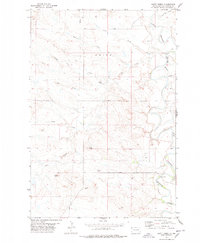
1977 Map of Scott Creek
USGS Topo · Published 1978About this map
The Little Missouri River meanders through the eastern section of this northwestern South Dakota landscape, defining a region where water and topography dictated movement and survival. In the mid-1970s, the terrain was marked by numerous intermittent watercourses like Scott Creek, Wagoneer Creek, and the evocatively named Dipping Vat Draw, illustrating the ranching heritage of Harding County. Notable landforms such as Bleak Butte and Profile Butte rise above the drainage basins, serving as permanent landmarks in an area of sparse settlement.
Find a feature on this map
18 named features on this map. Tap any name to fly to it.
Don’t see what you’re looking for? This feature index may not catch every label — zoom into the map to look around manually.
Map Details
Editions of this 1977 Scott Creek Map
This is the sole edition of this map. No revisions or reprints were ever made.
Other maps of this area

1935 · Buffalo
USGS Topo · 1:125,000

1954 · Lemmon
USGS Topo · 1:250,000

1954 · Ekalaka
USGS Topo · 1:250,000

1956 · Ekalaka
USGS Topo · 1:250,000

1957 · Lemmon
USGS Topo · 1:250,000

1958 · Ekalaka
USGS Topo · 1:250,000

1965 · Ekalaka
USGS Topo · 1:250,000

1973 · Gallup Creek
USGS Topo · 1:24,000

1974 · Caroline Butte
USGS Topo · 1:24,000
1977 · Doaks Butte
USGS Topo · 1:24,000