
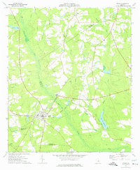
1974 Map of Scott
USGS Topo · Published 1976About this map
The town of Scott sits at a crossroads of county lines and watercourses, positioned where the Laurens and Johnson County boundaries meet. This mid-1970s landscape is defined by its rural connectivity, anchored by an Old Railroad Grade that cuts diagonally across the terrain, serving as a legacy of former transport routes. The region is densely populated with community landmarks, particularly a high concentration of country churches and family cemeteries that offer significant value for genealogical research.
Find a feature on this map
29 named features on this map. Tap any name to fly to it.
Don’t see what you’re looking for? This feature index may not catch every label — zoom into the map to look around manually.
Map Details
Editions of this 1974 Scott Map
This is the sole edition of this map. No revisions or reprints were ever made.
Other maps of this area

1957 · Macon
USGS Topo · 1:250,000

1958 · Macon
USGS Topo · 1:250,000

1964 · Macon
USGS Topo · 1:250,000

1971 · Soperton North
USGS Topo · 1:24,000

1971 · Rockledge
USGS Topo · 1:24,000

1974 · Kite
USGS Topo · 1:24,000

1974 · Wrightsville
USGS Topo · 1:24,000

1974 · East Dublin
USGS Topo · 1:24,000

1974 · Lovett
USGS Topo · 1:24,000
1974 · Adrian
USGS Topo · 1:24,000