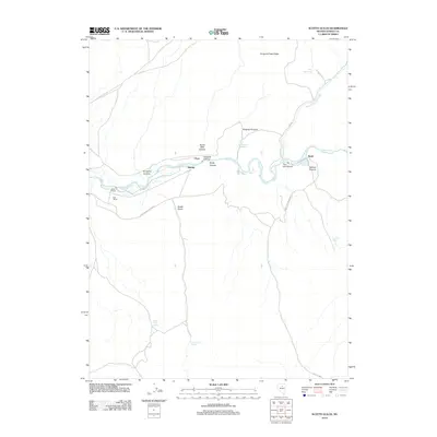
2012 Map of Scotts Gulch
USGS Topo · Published 2012About this map
The Humboldt River carves a deep path through the high desert of Eureka County, creating a series of dramatic geographic bottlenecks including Emigrant Canyon, Palisade Canyon, and Stone Wall Canyon. This corridor has long served as a vital transit route across the Great Basin, evidenced by the clustered settlements and rail-side locations of Harney, Cluro, and Barth. The map documents a landscape where water is the primary arbiter of settlement, with cattle operations like Rose Ranch and Bell Ranch established near the river's life-giving flow.
Find a feature on this map
23 named features on this map. Tap any name to fly to it.
Don’t see what you’re looking for? This feature index may not catch every label — zoom into the map to look around manually.
Map Details
Editions of this 2012 Scotts Gulch Map
This is the sole edition of this map. No revisions or reprints were ever made.
Other maps of this area

1952 · Pine Valley
USGS Topo · 1:62,500

1952 · Carlin
USGS Topo · 1:62,500

1955 · Winnemucca
USGS Topo · 1:250,000

1957 · Frenchie Creek
USGS Topo · 1:62,500

1957 · Beowawe
USGS Topo · 1:62,500

1958 · Winnemucca
USGS Topo · 1:250,000

1962 · Winnemucca
USGS Topo · 1:250,000

1985 · Scotts Gulch
USGS Topo · 1:24,000
1985 · Frenchie Flat
USGS Topo · 1:24,000
1985 · Tumbleweed Flat
USGS Topo · 1:24,000