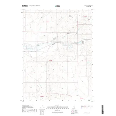
2018 Map of Scotts Gulch
USGS Topo · Published 2018About this map
The Humboldt River carves a central path through this portion of Eureka County, creating a narrow corridor of historical transit through the Great Basin. Small settlements such as Cluro, Harney, and Barth are situated along the river and rail route, serving as lonely outposts in a landscape dominated by complex terrain. The topography is defined by the steep ascents of Emigrant Pass Ridge and Kingerly Summit, which overlook a series of deep drainages including Stone Wall Canyon and Safford Canyon. To the south, the terrain descends from the Dry Hills into the northern reaches of Crescent Valley. Vital water sources for local livestock and wildlife are documented across the arid slopes, including Willy Billy Spring, Tunnel Spring, and Seven Tank Spring, which trace the precarious nature of life in this high-desert environment.
Find a feature on this map
28 named features on this map. Tap any name to fly to it.
Don’t see what you’re looking for? This feature index may not catch every label — zoom into the map to look around manually.
Map Details
Editions of this 2018 Scotts Gulch Map
This is the sole edition of this map. No revisions or reprints were ever made.
Other maps of this area

1952 · Pine Valley
USGS Topo · 1:62,500

1952 · Carlin
USGS Topo · 1:62,500

1955 · Winnemucca
USGS Topo · 1:250,000

1957 · Frenchie Creek
USGS Topo · 1:62,500

1957 · Beowawe
USGS Topo · 1:62,500

1958 · Winnemucca
USGS Topo · 1:250,000

1962 · Winnemucca
USGS Topo · 1:250,000

1985 · Scotts Gulch
USGS Topo · 1:24,000
1985 · Frenchie Flat
USGS Topo · 1:24,000
1985 · Tumbleweed Flat
USGS Topo · 1:24,000