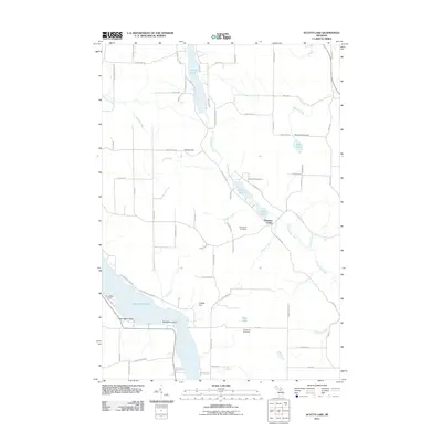
2011 Map of Scotts Lake
USGS Topo · Published 2011About this map
The Intermediate River chain of lakes defines this northern Michigan landscape, where water and topography dictated the development of Central Lake Township. The river flows south through Sixmile Lake, Scotts Lake, and Beals Lake before entering the northern reach of Intermediate Lake. High points like Bunker Hill and Dingle Hill rise above the basin, providing the backdrop for local landmarks such as Pleasant Valley Camp and Snowflake Camp. For genealogists and local historians, the sheet is a precise record of rural property locations and community centers, specifically identifying several historic burial grounds including Morehouse Cemetery, Densmore Cemetery, and Flewelling Cemetery. The road network follows a classic grid pattern established by early survey lines, with names like Dingman School Rd and Mohrmann Bridge Rd reflecting the area's agricultural and educational heritage.
Find a feature on this map
77 named features on this map. Tap any name to fly to it.
Don’t see what you’re looking for? This feature index may not catch every label — zoom into the map to look around manually.
Map Details
Editions of this 2011 Scotts Lake Map
This is the sole edition of this map. No revisions or reprints were ever made.
Other maps of this area

1954 · Central Lake
USGS Topo · 1:62,500

1954 · Traverse City
USGS Topo · 1:250,000

1955 · Cheboygan
USGS Topo · 1:250,000

1956 · Mancelona
USGS Topo · 1:62,500

1957 · Elk Rapids
USGS Topo · 1:62,500

1958 · Cheboygan
USGS Topo · 1:250,000

1958 · Traverse City
USGS Topo · 1:250,000

1961 · Boyne City
USGS Topo · 1:62,500

1975 · Mancelona NE
USGS Topo · 1:24,000

1975 · Mancelona NW
USGS Topo · 1:24,000