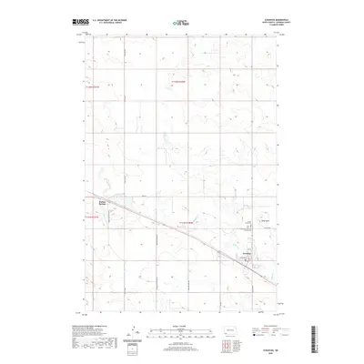
2020 Map of Scranton
USGS Topo · Published 2020About this map
Scranton serves as the primary hub of this southwestern North Dakota landscape, situated along a transportation corridor that includes Scranton Rd and Hamilton St. The township-and-range grid system, marked by boundaries like t131n r100w, organizes the prairie terrain around the winding path of Buffalo Cr. To the west, the settlement of Buffalo Springs sits near the intersection of 137th Ave SW and 86th St, illustrating the dispersed nature of rural communities in Bowman County. Genealogists and local historians will find several significant burial sites, including the Sacred Heart Cem and the combined Peace Lutheran Cem - Scranton Cem. The topographical relief is punctuated by Moga Butte in the east, providing a distinct landmark against the surrounding agricultural sections.
Find a feature on this map
23 named features on this map. Tap any name to fly to it.
Don’t see what you’re looking for? This feature index may not catch every label — zoom into the map to look around manually.
Map Details
Editions of this 2020 Scranton Map
This is the sole edition of this map. No revisions or reprints were ever made.
Other maps of this area

1953 · Dickinson
USGS Topo · 1:250,000

1957 · Dickinson
USGS Topo · 1:250,000

1969 · Scranton
USGS Topo · 1:24,000

1969 · Gascoyne
USGS Topo · 1:24,000

1969 · Scranton NE
USGS Topo · 1:24,000

1973 · Warnke Hill
USGS Topo · 1:24,000

1973 · Mineral Springs
USGS Topo · 1:24,000

1973 · Talbot Butte
USGS Topo · 1:24,000

1973 · Amidon SE
USGS Topo · 1:24,000
1973 · Scranton SW
USGS Topo · 1:24,000