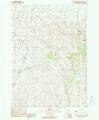
1990 Map of Scratch Post Butte
USGS Topo · Published 1990About this map
The Indian Treaty Boundary cuts diagonally across this high-desert landscape in Malheur County, marking a significant historical line through the terrain. Dominated by prominent volcanic landforms like Scratch Post Butte and Circle Butte, the area shows a complex drainage network where ephemeral and perennial waters including Blue Creek, Sheep Creek, and Wheaton Creek carve through the high plateaus. To the west, Smith Reservoir provides a critical water source in this arid environment, while Juniper Mountain rises in the eastern portion of the quadrangle. This 1990 provisional survey by the Geological Survey captures the specialized land use of the region, featuring numerous springs and several canyons, such as Deep Canyon, that define the local topography. The map illustrates how ranching and water management are adapted to the elevation, with features like the Clover Creek drainage and various unnamed four-wheel-drive tracks providing the primary access through the hills.
Find a feature on this map
16 named features on this map. Tap any name to fly to it.
Don’t see what you’re looking for? This feature index may not catch every label — zoom into the map to look around manually.
Map Details
Editions of this 1990 Scratch Post Butte Map
This is the sole edition of this map. No revisions or reprints were ever made.
Other maps of this area

1955 · Baker
USGS Topo · 1:250,000

1959 · Baker
USGS Topo · 1:250,000

1964 · Bridgeport
USGS Topo · 1:62,500

1964 · Brogan
USGS Topo · 1:62,500

1964 · Ironside
USGS Topo · 1:62,500

1966 · Clover Creek Ranch
USGS Topo · 1:62,500

1980 · Brogan
USGS Topo · 1:100,000
1990 · Brady Creek
USGS Topo · 1:24,000
1990 · Ironside
USGS Topo · 1:24,000
1990 · Cow Valley West
USGS Topo · 1:24,000