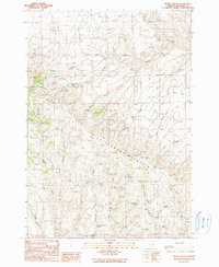
1990 Map of Brady Creek
USGS Topo · Published 1990About this map
Cottonwood Mountain dominates the central landscape of this high-elevation corner of Malheur County, providing a backdrop for the isolated Juniper Mtn Ranch near Juniper Mtn. The 1990 survey captures a region defined by its water management and livestock history, where numerous natural water sources like Grey Horse Spring, Chokecherry Spring, and Swede Spring are critical to the arid terrain. Man-made infrastructure is represented by the Upper Buckbrush Reservoir and the lower Buckbrush Reservoir in the southern reaches. The drainage patterns are complex, with Brady Creek and Buckbrush Creek cutting through the slopes, while the presence of a Radio Facility and Radio Tower atop the mountain peaks highlights the area's role for modern communications. The map also traces a network of 4wd tracks and trails connecting various landmarks like West Cairn and Crest Cairn.
Find a feature on this map
27 named features on this map. Tap any name to fly to it.
Don’t see what you’re looking for? This feature index may not catch every label — zoom into the map to look around manually.
Map Details
Editions of this 1990 Brady Creek Map
This is the sole edition of this map. No revisions or reprints were ever made.
Other maps of this area

1955 · Baker
USGS Topo · 1:250,000

1959 · Baker
USGS Topo · 1:250,000

1964 · Bridgeport
USGS Topo · 1:62,500

1964 · Brogan
USGS Topo · 1:62,500

1964 · Ironside
USGS Topo · 1:62,500

1966 · Clover Creek Ranch
USGS Topo · 1:62,500

1980 · Brogan
USGS Topo · 1:100,000
1990 · Scratch Post Butte
USGS Topo · 1:24,000
1990 · Cow Valley West
USGS Topo · 1:24,000
1990 · Buckbrush Creek
USGS Topo · 1:24,000