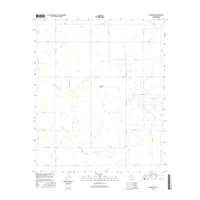
2016 Map of Seagraves SE
USGS Topo · Published 2016About this map
McKenzie Draw carves a subtle path through this section of the High Plains, where the landscape is defined by its agricultural and ranching layout. In the mid-2010s, this area of Gaines County was organized by a rigid grid of county roads, including Co Rd 122 and Co Rd 103, illustrating the systematic division of the West Texas Llano Estacado. The presence of Mamaw & Papaw's Rd suggests a more personal, family-rooted history within the broader rural framework dominated by arteries like Ranch Rd 1429. This survey is particularly useful for those tracing the modern geography of large-scale land holdings and the local road networks that serve this remote ranching region.
Find a feature on this map
20 named features on this map. Tap any name to fly to it.
Don’t see what you’re looking for? This feature index may not catch every label — zoom into the map to look around manually.
Map Details
Editions of this 2016 Seagraves SE Map
This is the sole edition of this map. No revisions or reprints were ever made.
Other maps of this area

1954 · Hobbs
USGS Topo · 1:250,000

1958 · Hobbs
USGS Topo · 1:250,000

1969 · Loop
USGS Topo · 1:24,000

1970 · Seagraves SW
USGS Topo · 1:24,000

1970 · Seminole NE
USGS Topo · 1:24,000

1970 · Seagraves SE
USGS Topo · 1:24,000

1970 · McKenzie Lake NW
USGS Topo · 1:24,000

1970 · Seagraves
USGS Topo · 1:24,000
1970 · Loop SW
USGS Topo · 1:24,000

1970 · Seagraves NW
USGS Topo · 1:24,000