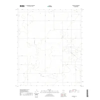
2019 Map of Seagraves SE
USGS Topo · Published 2019About this map
McKenzie Draw meanders across this portion of Gaines County, providing a natural drainage corridor through the characteristic grid of the Llano Estacado. The landscape is primarily defined by its agricultural and ranching infrastructure, organized around an extensive network of county roads such as Co Rd 116 and Co Rd 122. While much of the area follows a strict section-line orientation, several uniquely named private thoroughfares like Mamaw & Papaw's Rd and Pr Rd 840 suggest family-owned tracts and long-standing local ties. The presence of Ranch Rd 1429 indicates the importance of larger-scale ranching operations in this high plains region, where the terrain is punctuated by numerous small depressions and intermittent catchments that collect after West Texas rains.
Find a feature on this map
20 named features on this map. Tap any name to fly to it.
Don’t see what you’re looking for? This feature index may not catch every label — zoom into the map to look around manually.
Map Details
Editions of this 2019 Seagraves SE Map
This is the sole edition of this map. No revisions or reprints were ever made.
Other maps of this area

1954 · Hobbs
USGS Topo · 1:250,000

1958 · Hobbs
USGS Topo · 1:250,000

1969 · Loop
USGS Topo · 1:24,000

1970 · Seagraves SW
USGS Topo · 1:24,000

1970 · Seminole NE
USGS Topo · 1:24,000

1970 · Seagraves SE
USGS Topo · 1:24,000

1970 · McKenzie Lake NW
USGS Topo · 1:24,000

1970 · Seagraves
USGS Topo · 1:24,000
1970 · Loop SW
USGS Topo · 1:24,000

1970 · Seagraves NW
USGS Topo · 1:24,000