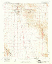
1959 Map of Searchlight
USGS Topo · Published 1960About this map
The mining district of Searchlight dominates this late-1950s survey, revealing a landscape defined by gold and silver extraction at the edge of the Piute Valley. The township is surrounded by a dense concentration of historical claims, including the Blossom Mine, Quartette Mine, and the Big Casino Mines. These workings, along with the Cem and local Landing Strip, illustrate the community's mid-century industrial footprint before later conservation efforts transformed the region.
Find a feature on this map
38 named features on this map. Tap any name to fly to it.
Don’t see what you’re looking for? This feature index may not catch every label — zoom into the map to look around manually.
Map Details
Editions of this 1959 Searchlight Map
3 editions found
Other maps of this area

1886 · Camp Mohave
USGS Topo · 1:250,000

1892 · Camp Mohave
USGS Topo · 1:250,000

1910 · Ivanpah
USGS Topo · 1:250,000

1912 · Ivanpah
USGS Topo · 1:250,000

1926 · Nelson
USGS Topo · 1:96,000

1926 · Mohave City
USGS Topo · 1:96,000

1942 · Camp Mohave
USGS Topo · 1:250,000

1942 · Ivanpah
USGS Topo · 1:250,000

1947 · Kingman
USGS Topo · 1:250,000

1948 · Kingman
USGS Topo · 1:250,000