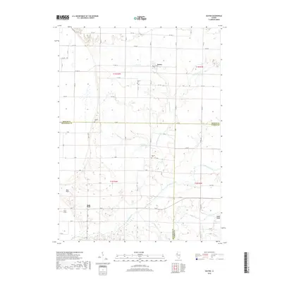
2018 Map of Seaton
USGS Topo · Published 2018About this map
Seaton and the surrounding agricultural landscapes of western Illinois are captured here where Mercer, Henderson, and Warren counties meet. The terrain is defined by the meandering courses of North Henderson Creek and the southern Cedar Creek, which carve gentle valleys through the prairie. Near the western edge of the quadrangle, Bald Bluff rises as a distinct landmark above the drainage of Goose Pond. Small community centers and family heritage are preserved through several documented burial grounds, including McClure Cem and Hawkins Cem. The rural infrastructure is characterized by a precise grid of roads like 1st Ave and Co Hwy 16, while the small village of Little York anchors the southeastern corner. This survey documents the persistent rural character and hydrology of the region, from the wetlands of Kissinger Lake to the scattered farmsteads connected by well-established county routes.
Find a feature on this map
66 named features on this map. Tap any name to fly to it.
Don’t see what you’re looking for? This feature index may not catch every label — zoom into the map to look around manually.
Map Details
Editions of this 2018 Seaton Map
This is the sole edition of this map. No revisions or reprints were ever made.
Other maps of this area

1921 · Monmouth
USGS Topo · 1:62,500

1923 · Monmouth
USGS Topo · 1:62,500

1923 · Alexis
USGS Topo · 1:62,500

1925 · Alexis
USGS Topo · 1:62,500

1934 · Oquawka
USGS Topo · 1:48,000

1935 · Keithsburg
USGS Topo · 1:48,000

1940 · Oquawka
USGS Topo · 1:62,500

1941 · Keithsburg
USGS Topo · 1:62,500
1953 · Aledo East
USGS Topo · 1:24,000
1953 · Joy
USGS Topo · 1:24,000