
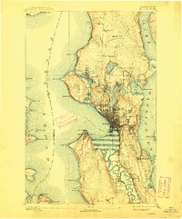
1894 Map of Seattle
USGS Topo · Published 1903About this map
Seattle sits at a pivotal moment of expansion in the mid-1890s, caught between the salt waters of Elliott Bay and the vast Lake Washington. This survey reveals a landscape of independent satellite towns before their full incorporation into the city, including Ballard, West Seattle, and South Seattle. The complex hydrology of the region is evident in the winding Dwamish River and its expansive wetlands, long before the massive dredging and filling projects of the 20th century transformed the industrial district. Rail networks like the Seattle Lake Shore and Eastern R.R. and the Seattle and Montana R.R. trace the shorelines, while early neighborhoods such as Fremont, Latona, and Ravenna emerge near the shores of Lake Union and Green Lake. The map also captures several settlements along the Lake Washington shore that are now part of the city's urban fabric, such as Columbia City and Pontiac.
Find a feature on this map
68 named features on this map. Tap any name to fly to it.
Don’t see what you’re looking for? This feature index may not catch every label — zoom into the map to look around manually.
Map Details
Editions of this 1894 Seattle Map
2 editions found
Other maps of this area

1895 · Snohomish
USGS Topo · 1:125,000

1897 · Tacoma
USGS Topo · 1:125,000

1897 · Seattle
USGS Topo · 1:125,000

1900 · Tacoma
USGS Topo · 1:125,000

1908 · Seattle
USGS Topo · 1:62,500

1909 · Seattle Special
USGS Topo · 1:62,500

1937 · Port Orchard
USGS Topo · 1:62,500

1937 · Port Gamble
USGS Topo · 1:62,500

1940 · Port Gamble
USGS Topo · 1:62,500

1942 · Edmonds
USGS Topo · 1:62,500