
1983 Map of Seattle North
USGS Topo · Published 1983About this map
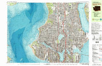
Seattle neighborhoods and maritime facilities dominate this 1980s-era study, detailing the complex urban-water interface between Puget Sound and Lake Washington. The map highlights a city defined by its topography and infrastructure, from the residential grids of Ballard and Northgate to the industrial activity at Salmon Bay Fishermens Terminal. Significant institutional footprints are visible, including the expansive University of Washington campus and the Fort Lawton Mil Res on the western tip of Magnolia.
Find a feature on this map
126 named features on this map. Tap any name to fly to it.
Don’t see what you’re looking for? This feature index may not catch every label — zoom into the map to look around manually.
Map Details
Editions of this 1983 Seattle North Map
2 editions found
Other maps of this area

1894 · Seattle
USGS Topo · 1:62,500

1895 · Snohomish
USGS Topo · 1:125,000

1897 · Seattle
USGS Topo · 1:125,000

1908 · Seattle
USGS Topo · 1:62,500

1909 · Seattle Special
USGS Topo · 1:62,500

1937 · Port Orchard
USGS Topo · 1:62,500

1937 · Port Gamble
USGS Topo · 1:62,500

1940 · Port Gamble
USGS Topo · 1:62,500

1942 · Edmonds
USGS Topo · 1:62,500

1944 · Everett
USGS Topo · 1:62,500