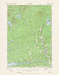
1940 Map of Sebec
USGS Topo · Published 1965About this map
Katahdin Iron Works stands as a focal point of industrial history in this Maine landscape, marking where ore from Ore Mountain Pond was once processed. The railroad network is particularly prominent, showing the Canadian Pacific and Bangor and Aroostook lines converging at Brownville Junction. These tracks facilitated the movement of timber and iron through the river valleys of the West Branch Pleasant River and the East Branch Pleasant River.
Find a feature on this map
119 named features on this map. Tap any name to fly to it.
Don’t see what you’re looking for? This feature index may not catch every label — zoom into the map to look around manually.
Map Details
Editions of this 1940 Sebec Map
4 editions found
Other maps of this area

1932 · Dover-Foxcroft
USGS Topo · 1:48,000

1933 · Boyd Lake
USGS Topo · 1:62,500

1933 · Guilford
USGS Topo · 1:62,500

1935 · Dover-Foxcroft
USGS Topo · 1:62,500

1937 · Guilford
USGS Topo · 1:62,500

1940 · Sebec
USGS Topo · 1:48,000

1943 · Sebec
USGS Topo · 1:62,500

1947 · Schoodic
USGS Topo · 1:62,500

1949 · Schoodic
USGS Topo · 1:62,500

1950 · Sebec Lake
USGS Topo · 1:62,500