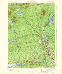
1943 Map of Sebec
USGS Topo · Published 1943About this map
Katahdin Iron Works stands as a focal point in this Piscataquis County landscape, marking a legacy of 19th-century industrial ambition in the Maine woods. The mid-20th-century topography reveals a complex network of resource extraction and transit, where the Canadian Pacific railroad cuts through the terrain to serve Brownville Junction. Small rural centers like Barnard and Mooresville are depicted alongside their essential local institutions, including the Barnard Sch and Williamsburg Sch. Along the southern edge, the shores of Sebec Lake are dotted with boat access points such as Greeley Landing and Parson Landing, reflecting the area's transition toward seasonal recreation and timber management. The map details numerous family-named peaks and hills, including Ebeemee Mountain and Silver Lake, illustrating the varied elevations of the central Maine highlands.
Find a feature on this map
123 named features on this map. Tap any name to fly to it.
Don’t see what you’re looking for? This feature index may not catch every label — zoom into the map to look around manually.
Map Details
Editions of this 1943 Sebec Map
4 editions found
Other maps of this area

1932 · Dover-Foxcroft
USGS Topo · 1:48,000

1933 · Boyd Lake
USGS Topo · 1:62,500

1933 · Guilford
USGS Topo · 1:62,500

1935 · Dover-Foxcroft
USGS Topo · 1:62,500

1937 · Guilford
USGS Topo · 1:62,500

1940 · Sebec
USGS Topo · 1:48,000

1943 · Sebec
USGS Topo · 1:62,500

1947 · Schoodic
USGS Topo · 1:62,500

1949 · Schoodic
USGS Topo · 1:62,500

1950 · Sebec Lake
USGS Topo · 1:62,500