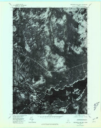
1977 Map of Seboomook Lake West
USGS Topo · Published 1981About this map
Pittston Farm sits at the vital junction where the North Branch Penobscot River meets the Penobscot River, marking a historic hub of logging activity in the Maine woods. This 1977 orthophotoquad captures the landscape at a time when industrial forest management relied on a network of remote outposts and waterways. The dark expanse of Seboomook Lake dominates the southeast, its irregular shoreline shaped by the natural flow of the river system. Multiple tributaries, including the West Branch, East Branch, and Gulliver Brook, drain the densely forested northern sections of the quadrangle. The aerial imagery provides a clear view of the logging roads and clearings that characterize the Somerset County wilderness, contrasting the managed timberlands with the ancient watercourses that once served as the primary transport for the region's timber harvest.
Find a feature on this map
8 named features on this map. Tap any name to fly to it.
Don’t see what you’re looking for? This feature index may not catch every label — zoom into the map to look around manually.
Map Details
Editions of this 1977 Seboomook Lake West Map
This is the sole edition of this map. No revisions or reprints were ever made.
Other maps of this area

1949 · Jackman
USGS Topo · 1:250,000

1954 · Seboomook Lake
USGS Topo · 1:62,500

1954 · St. John Pond
USGS Topo · 1:62,500

1954 · Presque Isle
USGS Topo · 1:250,000

1954 · Millinocket
USGS Topo · 1:250,000

1956 · Penobscot Lake
USGS Topo · 1:62,500

1957 · Norris Brook
USGS Topo · 1:62,500

1958 · Presque Isle
USGS Topo · 1:250,000

1958 · Millinocket
USGS Topo · 1:250,000

1958 · Saint John Pond
USGS Topo · 1:62,500
Featured Places
- Comstock Township, ME
- T4 R17 WELS, ME
- Pittston Academy Grant, ME
- Plymouth Township, ME
- Somerset County, ME