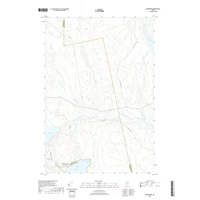
2018 Map of Seboomook
USGS Topo · Published 2018About this map
Seboomook sits at the northern tip of Moosehead Lake where the land transitions into the dense woods of the Maine North Woods. This territory is defined by the intersection of major waterways, specifically the West Branch Penobscot River as it flows eastward and the northern reaches of Seboomook Lake. The boundary between Somerset and Piscataquis counties runs vertically through this landscape, dividing a region historically vital for timber transport and remote recreation. The map details the drainage patterns of numerous tributaries like Luther Brook, Elm Stream, and Russell Stream, which feed into larger bodies such as Cassidy Deadwater. Transportation is limited to rugged access ways including Burbank Rd and Seboomook Dam Rd, reflecting a landscape geared toward seasonal navigation and natural resource management rather than permanent settlement.
Find a feature on this map
19 named features on this map. Tap any name to fly to it.
Don’t see what you’re looking for? This feature index may not catch every label — zoom into the map to look around manually.
Map Details
Editions of this 2018 Seboomook Map
This is the sole edition of this map. No revisions or reprints were ever made.
Other maps of this area

1954 · Seboomook Lake
USGS Topo · 1:62,500

1954 · North East Carry
USGS Topo · 1:62,500

1954 · Caucomgomoc Lake
USGS Topo · 1:62,500

1954 · St. John Pond
USGS Topo · 1:62,500

1954 · Presque Isle
USGS Topo · 1:250,000

1954 · Millinocket
USGS Topo · 1:250,000

1958 · Presque Isle
USGS Topo · 1:250,000

1958 · Millinocket
USGS Topo · 1:250,000

1958 · Caucomgomoc Lake
USGS Topo · 1:62,500

1958 · Saint John Pond
USGS Topo · 1:62,500
Featured Places
- Northeast Carry Township, ME
- Big W Township, ME
- Elm Stream Township, ME
- T4 R15 WELS, ME
- Seboomook, Big W Township