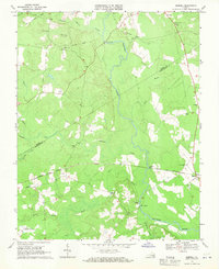
1968 Map of Sebrell
USGS Topo · Published 1970About this map
The Nottoway River meanders through this portion of Southampton and Sussex counties, defining a landscape shaped by its dense swampy tributaries and rail infrastructure. In the late 1960s, the Norfolk and Western railway served as a primary east-west artery, passing through the community of Sebrell. The map reveals a dispersed settlement pattern typical of the Virginia coastal plain, marked by numerous small churches that served as local anchors, such as Hickory Hill Ch, Mill Neck Ch, and St Johns Ch. Further south, the Southampton Correctional Farm occupies a significant tract near Three Creek. The presence of several old crossings, including Peters Bridge, Westbrook Bridge, and Careys Bridge, illustrates the historical importance of the river for local transit. The topography is largely defined by low-lying wetlands like Hunting Quarter Swamp and Hornet Swamp, which are interspersed with cleared agricultural lands.
Find a feature on this map
31 named features on this map. Tap any name to fly to it.
Don’t see what you’re looking for? This feature index may not catch every label — zoom into the map to look around manually.
Map Details
Editions of this 1968 Sebrell Map
2 editions found
Other maps of this area

1919 · Jarratt
USGS Topo · 1:62,500

1919 · Homeville
USGS Topo · 1:48,000

1919 · Boykins
USGS Topo · 1:48,000

1919 · Arringdale
USGS Topo · 1:48,000

1920 · Homeville
USGS Topo · 1:62,500

1920 · Boykins
USGS Topo · 1:62,500

1920 · Arringdale
USGS Topo · 1:62,500

1942 · Arringdale
USGS Topo · 1:62,500

1943 · Sebrell
USGS Topo · 1:31,680

1943 · Manry
USGS Topo · 1:31,680