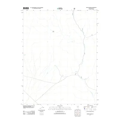
2011 Map of Secret Basin
USGS Topo · Published 2011About this map
Secret Basin defines this high-desert landscape in Nye County, where water is the primary organizing principle for travel and survival. The drainage of Cottonwood Creek runs through the eastern portion of the quadrangle, serving as a corridor for Forest Service routes such as 451 and 450. This 2011 survey reveals a territory marked by dispersed water sources that likely dictated historical livestock movement and backcountry access. Named points of interest include Mississippi Springs in the west and a cluster of springs including Mud Spring, Barrel Spring, and Gale Spring further south. These features, along with Bank Spring, represent the vital water network that supported ranching and prospecting in this arid environment, connected today by primitive roads like NFD 451 RD.
Find a feature on this map
11 named features on this map. Tap any name to fly to it.
Don’t see what you’re looking for? This feature index may not catch every label — zoom into the map to look around manually.
Map Details
Editions of this 2011 Secret Basin Map
This is the sole edition of this map. No revisions or reprints were ever made.
Other maps of this area

1907 · Tonopah
USGS Topo · 1:250,000

1908 · Tonopah
USGS Topo · 1:250,000

1956 · Tonopah
USGS Topo · 1:250,000

1959 · Tonopah
USGS Topo · 1:250,000

1962 · Tonopah
USGS Topo · 1:250,000

1964 · San Antonio Ranch
USGS Topo · 1:62,500
1980 · Cloverdale Ranch
USGS Topo · 1:24,000
1980 · Outlaw Springs NE
USGS Topo · 1:24,000

1980 · Secret Basin
USGS Topo · 1:24,000
1980 · Farrington Canyon
USGS Topo · 1:24,000