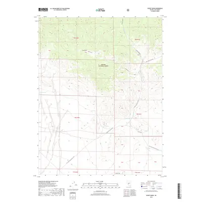
2018 Map of Secret Basin
USGS Topo · Published 2018About this map
Secret Basin serves as the topographic centerpiece of this high-altitude landscape within the Toiyabe National Forest. The map documents a network of vital water sources in a complex mountain environment, including Mississippi Springs, Mud Spring, and Bank Spring. The terrain is characterized by dramatic elevation changes, rising toward Rainier Mtn in the south. The human footprint is defined largely by administrative forest infrastructure, specifically Natl Forest Develop Road 451 Rd and Natl Forest Develop Road 450 Rd, which provide access through the deep cuts of Barrel Spring-Dry Canyon. Broad upland areas like Barney Meadows suggest the seasonal grazing patterns typical of this region of Nye County, while the numerous mapped springs indicate the essential points of reliability for local land use and transit.
Find a feature on this map
21 named features on this map. Tap any name to fly to it.
Don’t see what you’re looking for? This feature index may not catch every label — zoom into the map to look around manually.
Map Details
Editions of this 2018 Secret Basin Map
This is the sole edition of this map. No revisions or reprints were ever made.
Other maps of this area

1907 · Tonopah
USGS Topo · 1:250,000

1908 · Tonopah
USGS Topo · 1:250,000

1956 · Tonopah
USGS Topo · 1:250,000

1959 · Tonopah
USGS Topo · 1:250,000

1962 · Tonopah
USGS Topo · 1:250,000

1964 · San Antonio Ranch
USGS Topo · 1:62,500
1980 · Cloverdale Ranch
USGS Topo · 1:24,000
1980 · Outlaw Springs NE
USGS Topo · 1:24,000

1980 · Secret Basin
USGS Topo · 1:24,000
1980 · Farrington Canyon
USGS Topo · 1:24,000