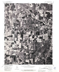
1980 Map of Sedalia West
USGS Topo · Published 1981About this map
Dresden and the western periphery of Sedalia anchor this orthophotoquad, which provides a high-altitude perspective on the Pettis County landscape as it existed in 1980. Unlike traditional topographic maps, this aerial imagery reveals the precise geometry of agricultural fields and the wooded corridors following the path of Muddy Creek and Flat Creek. The visual data captured here is particularly useful for identifying farmstead footprints and land-use patterns that may have shifted in subsequent decades. The western expansion of Sedalia is visible on the eastern edge of the sheet, showing the emerging residential and commercial layout near the intersection of major transit routes. To the south and west, the terrain transitions into more intensive farming tracts, punctuated by the drainage of Camp Branch.
Find a feature on this map
5 named features on this map. Tap any name to fly to it.
Don’t see what you’re looking for? This feature index may not catch every label — zoom into the map to look around manually.
Map Details
Editions of this 1980 Sedalia West Map
This is the sole edition of this map. No revisions or reprints were ever made.
Other maps of this area

1887 · Sedalia
USGS Topo · 1:125,000

1894 · Sedalia
USGS Topo · 1:125,000

1939 · Sweet Springs
USGS Topo · 1:62,500

1940 · Sweet Springs
USGS Topo · 1:62,500

1941 · Sweet Springs
USGS Topo · 1:62,500

1944 · Sedalia West
USGS Topo · 1:24,000

1944 · Sedalia East
USGS Topo · 1:24,000

1945 · Sweet Springs
USGS Topo · 1:62,500

1946 · Sedalia West
USGS Topo · 1:24,000

1946 · Sedalia East
USGS Topo · 1:24,000