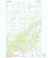
1987 Map of Sedan
USGS Topo · Published 1987About this map
Sedan serves as the quiet center of this high-elevation landscape in the late 1980s, situated near the headwaters of numerous mountain streams. The settlement is positioned along the western foothills of Battle Ridge, where the topography rises sharply into the protected lands of the Gallatin National Forest. This provisional survey highlights the intricate drainage network of the region, where the Middle Fork and South Fork converge near Flathead Creek in the north, while the southern reaches are dominated by the rugged slopes surrounding Nixon Peak.
Find a feature on this map
19 named features on this map. Tap any name to fly to it.
Don’t see what you’re looking for? This feature index may not catch every label — zoom into the map to look around manually.
Map Details
Editions of this 1987 Sedan Map
This is the sole edition of this map. No revisions or reprints were ever made.
Other maps of this area

1886 · Little Belt Mts.
USGS Topo · 1:250,000

1891 · Livingston
USGS Topo · 1:250,000

1893 · Livingston
USGS Topo · 1:250,000

1894 · Little Belt Mts.
USGS Topo · 1:250,000

1897 · Little Belt Mts.
USGS Topo · 1:250,000

1898 · Little Belt Mts.
USGS Topo · 1:250,000

1902 · Little Belt Mts.
USGS Topo · 1:250,000

1947 · Bozeman
USGS Topo · 1:250,000

1948 · Bozeman
USGS Topo · 1:250,000

1948 · White Sulphur Springs
USGS Topo · 1:250,000