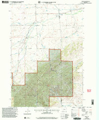
2000 Map of Sedan
USGS Topo · Published 2005About this map
Sedan sits at the intersection of mountain drainage and high-country ranching on the border of Gallatin and Park Counties. This landscape is defined by the sharp rise of Battle Ridge and the prominent Nixon Peak, where the Gallatin National Forest transitions into the valley floor. The settlement pattern is sparse, oriented around water sources like Cache Creek and Green Canyon Creek, with infrastructure limited to scattered structures such as a Storage Bin and a Corral. Local history is anchored by the small Cem located near the town center, serving the rural community that utilized the network of unimproved roads and 4wd trails. The map tracks the complex hydrology of the region, specifically the headwaters of the Middle Fork and South Fork Flathead Creek, which carve deep canyons through the northern reaches of the quadrangle.
Find a feature on this map
21 named features on this map. Tap any name to fly to it.
Don’t see what you’re looking for? This feature index may not catch every label — zoom into the map to look around manually.
Map Details
Editions of this 2000 Sedan Map
This is the sole edition of this map. No revisions or reprints were ever made.
Other maps of this area

1886 · Little Belt Mts.
USGS Topo · 1:250,000

1891 · Livingston
USGS Topo · 1:250,000

1893 · Livingston
USGS Topo · 1:250,000

1894 · Little Belt Mts.
USGS Topo · 1:250,000

1897 · Little Belt Mts.
USGS Topo · 1:250,000

1898 · Little Belt Mts.
USGS Topo · 1:250,000

1902 · Little Belt Mts.
USGS Topo · 1:250,000

1947 · Bozeman
USGS Topo · 1:250,000

1948 · Bozeman
USGS Topo · 1:250,000

1948 · White Sulphur Springs
USGS Topo · 1:250,000