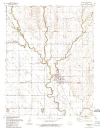
1989 Map of Sedgwick
USGS Topo · Published 1990About this map
The Little Arkansas River carves a winding path through this central Kansas landscape, where the town of Sedgwick serves as a primary hub near the border of Harvey and Sedgwick counties. This late 20th-century survey illustrates a region defined by its water network, including Emma Creek, Sand Creek, and Kisiwa Creek, which converge to support the local agriculture and industry. The presence of Sandpits near the riverbank suggests local resource extraction, while the Aqueduct and numerous pipelines indicate a sophisticated water and utility infrastructure.
Find a feature on this map
23 named features on this map. Tap any name to fly to it.
Don’t see what you’re looking for? This feature index may not catch every label — zoom into the map to look around manually.
Map Details
Editions of this 1989 Sedgwick Map
This is the sole edition of this map. No revisions or reprints were ever made.
Other maps of this area

1889 · Newton
USGS Topo · 1:125,000

1889 · Cheney
USGS Topo · 1:125,000

1889 · Wichita
USGS Topo · 1:125,000

1891 · Hutchinson
USGS Topo · 1:125,000

1891 · Cheney
USGS Topo · 1:125,000

1893 · Hutchinson
USGS Topo · 1:125,000

1894 · Wichita
USGS Topo · 1:125,000

1894 · Newton
USGS Topo · 1:125,000

1901 · Cheney
USGS Topo · 1:125,000

1941 · Maize
USGS Topo · 1:31,680