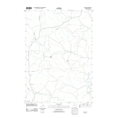
2012 Map of Seely
USGS Topo · Published 2012About this map
The Belle Fourche River winds through the southeastern corner of this landscape, anchoring a ranching district in Wyoming's Crook County. This territory is defined by its deep canyons and family-held lands, including the Pearson Ranch, Belle Ranch, and Nielsen Ranch. The terrain reveals a complex network of drainages such as Buck Cr, Medicine Cr, and Sourdough Cr that have shaped the high plains geography. Notable landmarks like Squaw Buttes and the dramatic Lovers Leap overlook the drainages, while the curious name of Steam Engine Canyon suggests a connection to early industrial history or machinery lost to time. Settlement is sparse, focused around the community of Seely and connected by rural routes like Bates Co Rd and Hwy 112. The presence of several named ranches, including the Ballou Ranch and Lee Ranch, highlights the enduring agricultural character of this corner of the state.
Find a feature on this map
27 named features on this map. Tap any name to fly to it.
Don’t see what you’re looking for? This feature index may not catch every label — zoom into the map to look around manually.
Map Details
Editions of this 2012 Seely Map
This is the sole edition of this map. No revisions or reprints were ever made.
Other maps of this area

1901 · Aladdin
USGS Topo · 1:125,000

1903 · Aladdin
USGS Topo · 1:125,000

1905 · Devils Tower
USGS Topo · 1:125,000

1954 · Strawberry Hill
USGS Topo · 1:24,000

1954 · Storm Hill
USGS Topo · 1:24,000

1954 · Gillette
USGS Topo · 1:250,000

1955 · Devils Tower
USGS Topo · 1:62,500

1955 · Gillette
USGS Topo · 1:250,000

1957 · Mona
USGS Topo · 1:62,500

1957 · Seely
USGS Topo · 1:62,500