
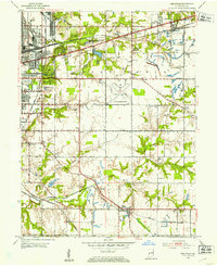
1952 Map of Seelyville
USGS Topo · Published 1953About this map
The eastern edges of Terre Haute define this mid-century landscape, where industrial expansion and early aviation meet the rural Wabash Valley. The presence of Hulman Airport and the Rose Polytechnic Institute illustrates a period of significant institutional growth. Transportation infrastructure is dense, with the historic National Road and Wabash Ave carrying traffic alongside a complex web of rail lines, including the Pennsylvania Railroad and the Milwaukee Road.
Find a feature on this map
65 named features on this map. Tap any name to fly to it.
Don’t see what you’re looking for? This feature index may not catch every label — zoom into the map to look around manually.
Map Details
Editions of this 1952 Seelyville Map
2 editions found
Other maps of this area

1908 · Clay City
USGS Topo · 1:48,000

1910 · Clay City
USGS Topo · 1:62,500

1940 · Lewis
USGS Topo · 1:24,000

1940 · Pimento
USGS Topo · 1:24,000

1941 · Seelyville
USGS Topo · 1:24,000

1941 · Terre Haute
USGS Topo · 1:24,000

1948 · Terre Haute
USGS Topo · 1:24,000

1950 · Rosedale
USGS Topo · 1:24,000

1950 · Brazil West
USGS Topo · 1:24,000

1950 · New Goshen
USGS Topo · 1:24,000