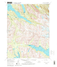
1981 Map of Seldovia B-4
USGS Topo · Published 1981About this map
Kachemak Bay State Park and the adjacent Kachemak Bay State Wilderness Park dominate this 1981 revision of the Kenai Peninsula, showcasing a complex landscape of coastal fjords and glaciated peaks. The map details the remote settlements and seasonal outposts along the shoreline, including San Juan and Little Tutka Bay, alongside numerous isolated cabins that suggest the region's reliance on maritime access. The drainage patterns of the Kenai Mountains are clearly defined, with the Jakolof River and Rocky River carving paths toward the sea.
Find a feature on this map
26 named features on this map. Tap any name to fly to it.
Don’t see what you’re looking for? This feature index may not catch every label — zoom into the map to look around manually.
Map Details
Editions of this 1981 Seldovia B-4 Map
This is the sole edition of this map. No revisions or reprints were ever made.
Other maps of this area

1946 · Seldovia C-5
USGS Topo · 1:63,360

1948 · Seldovia C-4
USGS Topo · 1:63,360

1949 · Seldovia C-4
USGS Topo · 1:62,500

1951 · Seldovia C-5
USGS Topo · 1:63,360

1951 · Seldovia
USGS Topo · 1:250,000

1951 · Seldovia B-5
USGS Topo · 1:63,360

1951 · Seldovia A-3
USGS Topo · 1:63,360

1951 · Seldovia B-4
USGS Topo · 1:63,360

1951 · Seldovia B-3
USGS Topo · 1:63,360

1951 · Seldovia A-4
USGS Topo · 1:63,360