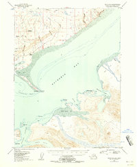
1948 Map of Seldovia C-4
USGS Topo · Published 1958About this map
The coastal curve of Kachemak Bay and its complex network of fjords and islands are documented in this mid-century survey. Along the northern shore, Millers Landing serves as a focal point near the prominent Homer Spit, which extends miles into the bay toward Coal Point. The geography of the late 1940s is defined by a reliance on maritime and aerial transport, evidenced by the Homer Airport and the Homer Light beacon. Industrial activity is concentrated near the shore, including a noted Sawmill and coal deposits located near the base of the spit.
Find a feature on this map
39 named features on this map. Tap any name to fly to it.
Don’t see what you’re looking for? This feature index may not catch every label — zoom into the map to look around manually.
Map Details
Editions of this 1948 Seldovia C-4 Map
2 editions found
Other maps of this area

1946 · Seldovia C-5
USGS Topo · 1:63,360

1946 · Seldovia D-5
USGS Topo · 1:63,360

1948 · Seldovia C-4
USGS Topo · 1:63,360

1949 · Seldovia C-4
USGS Topo · 1:62,500

1949 · Seldovia D-4
USGS Topo · 1:63,360

1951 · Seldovia C-5
USGS Topo · 1:63,360

1951 · Seldovia D-5
USGS Topo · 1:63,360

1951 · Seldovia D-4
USGS Topo · 1:63,360

1951 · Seldovia
USGS Topo · 1:250,000

1951 · Seldovia D-3
USGS Topo · 1:63,360