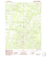
1987 Map of Seldovia D-5 SE
USGS Topo · Published 1987About this map
Nikolaevsk, Nahodka, and Kluchevaya anchor the central portion of this 1980s landscape on the Kenai Peninsula. The settlement pattern follows the drainage of the North Fork Anchor River, which winds through the central valley before meeting the main Anchor River in the south. The topography is defined by significant elevations like Epperson Knob, overlooking a network of unimproved roads and the historical Winter Trail that cuts across the northern terrain.
Find a feature on this map
13 named features on this map. Tap any name to fly to it.
Don’t see what you’re looking for? This feature index may not catch every label — zoom into the map to look around manually.
Map Details
Editions of this 1987 Seldovia D-5 SE Map
This is the sole edition of this map. No revisions or reprints were ever made.
Other maps of this area

1946 · Seldovia C-5
USGS Topo · 1:63,360

1946 · Seldovia D-5
USGS Topo · 1:63,360

1948 · Seldovia C-4
USGS Topo · 1:63,360

1949 · Seldovia C-4
USGS Topo · 1:62,500

1949 · Seldovia D-4
USGS Topo · 1:63,360

1951 · Seldovia C-5
USGS Topo · 1:63,360

1951 · Seldovia D-5
USGS Topo · 1:63,360

1951 · Seldovia D-4
USGS Topo · 1:63,360

1951 · Seldovia
USGS Topo · 1:250,000

1961 · Seldovia C-5
USGS Topo · 1:63,360