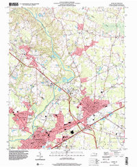
1998 Map of Selma
USGS Topo · Published 2000About this map
The Neuse River defines the western landscape of this Johnston County corridor during a period of significant infrastructure development. Between the growing hubs of Smithfield and Selma, the map reveals a dense network of civic and educational institutions, including the Johnston County Hospital, the Municipal Bldg, and several specialized campuses such as the County Training Sch and Harrison High Sch. The spatial arrangement of these landmarks alongside the Johnston Correctional Institute Unit 4230 reflects the area's role as a regional administrative and service center.
Find a feature on this map
60 named features on this map. Tap any name to fly to it.
Don’t see what you’re looking for? This feature index may not catch every label — zoom into the map to look around manually.
Map Details
Editions of this 1998 Selma Map
This is the sole edition of this map. No revisions or reprints were ever made.
Other maps of this area

1902 · Kenly
USGS Topo · 1:62,500

1903 · Kenly
USGS Topo · 1:62,500

1906 · Four Oaks
USGS Topo · 1:48,000

1908 · Four Oaks
USGS Topo · 1:62,500

1953 · Raleigh
USGS Topo · 1:250,000

1954 · Raleigh
USGS Topo · 1:250,000

1964 · Flowers
USGS Topo · 1:24,000

1964 · Selma
USGS Topo · 1:62,500

1964 · Clayton
USGS Topo · 1:24,000

1964 · Powhatan
USGS Topo · 1:24,000