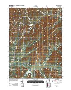
2011 Map of Selma
USGS Topo · Published 2011About this map
Selma and the surrounding Josephine County terrain are defined by the convergence of several major creek systems and mountain ridges. The southern portion of the area is anchored by Lake Selmac, created by the Lake Selmac Dam on McMullin Creek, while the northern section is marked by the small settlement of Wonder near the Wonder International Airport. This landscape reveals a pattern of rural settlement and private infrastructure, including the Backachers Ranch airstrip and various water management features like the Tall Timber Reservoir and its associated Tall Timber Dam. Family and local history is anchored at the Selma Cemetery and Deer Creek Cemetery, while the topography rises steeply from the Draper Valley floor toward Hayes Hill Summit and Mooney Mountain. The map also traces numerous Bureau of Land Management routes, such as BLM 38-8-21.5 Rd, indicating the area's relationship with federal forest lands.
Find a feature on this map
76 named features on this map. Tap any name to fly to it.
Don’t see what you’re looking for? This feature index may not catch every label — zoom into the map to look around manually.
Map Details
Editions of this 2011 Selma Map
This is the sole edition of this map. No revisions or reprints were ever made.
Other maps of this area

1908 · Grants Pass
USGS Topo · 1:125,000

1917 · Kerby
USGS Topo · 1:125,000

1918 · Kerby
USGS Topo · 1:125,000

1945 · Kerby
USGS Topo · 1:125,000

1954 · Cave Junction
USGS Topo · 1:62,500

1954 · Oregon Caves
USGS Topo · 1:62,500

1954 · Selma
USGS Topo · 1:62,500

1954 · Grants Pass
USGS Topo · 1:62,500

1955 · Medford
USGS Topo · 1:250,000

1957 · Medford
USGS Topo · 1:250,000