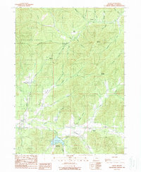
1989 Map of Selma
USGS Topo · Published 1989About this map
Selma sits at the heart of this valley landscape in the late 1980s, where the waters of Deer Creek and Anderson Creek descend from the surrounding peaks of the Siskiyou National Forest. The map documents a network of small settlements and transit points, including Wonder, Dryden, and the historic locations of Love Station and Anderson Station. To the south, Lake Selmac and the adjacent Lake Selmac County Park provide a clear recreational focal point amid the drainage basins of Mc Mullin Creek and Thompson Creek. Significant topographic landmarks such as Hayes Hill Summit and Wonder Mountain overlook the various gulches and creeks that define the local geography. For genealogists and local historians, the inclusion of the Deer Creek Cemetery and specifically named locations like Red Flat and Mooney Mountain offers precise points of interest for tracing family roots and land use in this part of Josephine County.
Find a feature on this map
44 named features on this map. Tap any name to fly to it.
Don’t see what you’re looking for? This feature index may not catch every label — zoom into the map to look around manually.
Map Details
Editions of this 1989 Selma Map
This is the sole edition of this map. No revisions or reprints were ever made.
Other maps of this area

1908 · Grants Pass
USGS Topo · 1:125,000

1917 · Kerby
USGS Topo · 1:125,000

1918 · Kerby
USGS Topo · 1:125,000

1945 · Kerby
USGS Topo · 1:125,000

1954 · Cave Junction
USGS Topo · 1:62,500

1954 · Oregon Caves
USGS Topo · 1:62,500

1954 · Selma
USGS Topo · 1:62,500

1954 · Grants Pass
USGS Topo · 1:62,500

1955 · Medford
USGS Topo · 1:250,000

1957 · Medford
USGS Topo · 1:250,000