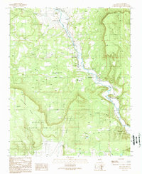
1989 Map of Sena
USGS Topo · Published 1989About this map
The Pecos River carves a winding path through the heart of this landscape, defining the settlement patterns of traditional northern New Mexico villages in the late 20th century. Clustered along the riverbanks and the San Miguel del Bado Tract No 2, small communities like Ribera, San Miguel, and Sena highlight a legacy of land grant history and riparian agriculture. The topography is dominated by the steep rises of Hurtado Mesa and Mesa Sacatosa, which hem in the valley and dictate the placement of local infrastructure, including the Valley School and several gravel pits and quarries. In the southeast, the terrain softens slightly as the river approaches Villanueva State Park, while the Santa Fe National Forest extends across the southwestern heights. This map documents a quiet, rural corridor where life remains centered on the water and the narrow fertile strips of the canyon floor.
Find a feature on this map
33 named features on this map. Tap any name to fly to it.
Don’t see what you’re looking for? This feature index may not catch every label — zoom into the map to look around manually.
Map Details
Editions of this 1989 Sena Map
This is the sole edition of this map. No revisions or reprints were ever made.
Other maps of this area

1890 · Bernal
USGS Topo · 1:125,000

1891 · Bernal
USGS Topo · 1:125,000

1894 · Bernal
USGS Topo · 1:125,000

1894 · Lamy
USGS Topo · 1:125,000

1954 · Santa Fe
USGS Topo · 1:250,000

1958 · Santa Fe
USGS Topo · 1:250,000

1960 · Villanueva
USGS Topo · 1:62,500

1963 · Aurora
USGS Topo · 1:24,000
1963 · San Juan
USGS Topo · 1:24,000
1966 · Laguna Ortiz
USGS Topo · 1:24,000