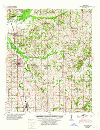
1944 Map of Senatobia
USGS Topo · Published 1964About this map
The Arkabutla Reservoir dominates the northwestern landscape of this survey, a significant flood control project on the Coldwater River that reshaped the local geography just before mid-century. This map illustrates the transition from riverine bottomlands to the interior uplands of Tate County, where a dense network of country schools and churches like Bethlehem African Ch and Johnsons Chapel Sch define the rural social structure. The Illinois Central railroad corridor serves as the primary industrial axis, anchoring the larger settlements of Coldwater and Senatobia.
Find a feature on this map
102 named features on this map. Tap any name to fly to it.
Don’t see what you’re looking for? This feature index may not catch every label — zoom into the map to look around manually.
Map Details
Editions of this 1944 Senatobia Map
3 editions found
Other maps of this area

1932 · Horn Lake
USGS Topo · 1:48,000

1932 · Sledge
USGS Topo · 1:48,000

1932 · Crenshaw
USGS Topo · 1:62,500

1935 · Crenshaw
USGS Topo · 1:62,500

1935 · Horn Lake
USGS Topo · 1:62,500

1935 · Sledge
USGS Topo · 1:62,500

1939 · Sledge
USGS Topo · 1:62,500

1940 · Oxford
USGS Topo · 1:62,500

1943 · Oxford
USGS Topo · 1:62,500

1944 · Senatobia
USGS Topo · 1:62,500