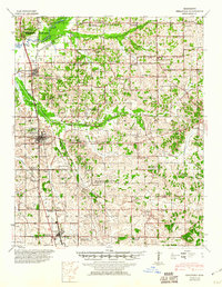
1944 Map of Senatobia
USGS Topo · Published 1960About this map
Arkabutla Reservoir dominates the northwestern corner of this landscape, its flood stage and pool levels newly established under the Flood Control Act as of the mid-1940s. The Coldwater River feeds this basin, while the Illinois Central Railroad provides the primary north-south transportation corridor through Coldwater, Senatobia, and Como. The map reveals a densely settled agricultural region defined by dozens of local institutions that combined education and faith, such as the New Garden Ch Sch & Cem and Ebenezer Ch Sch & Cem. Genealogists will find a wealth of family-named landmarks including the Brower Fam Cem and Wright Fam Cem. The presence of the N W Mississippi Jr College in Senatobia and the Bethlehem African Ch highlights the social and educational infrastructure of Tate County and northern Panola County during this era.
Find a feature on this map
133 named features on this map. Tap any name to fly to it.
Don’t see what you’re looking for? This feature index may not catch every label — zoom into the map to look around manually.
Map Details
Editions of this 1944 Senatobia Map
3 editions found
Other maps of this area

1932 · Horn Lake
USGS Topo · 1:48,000

1932 · Sledge
USGS Topo · 1:48,000

1932 · Crenshaw
USGS Topo · 1:62,500

1935 · Crenshaw
USGS Topo · 1:62,500

1935 · Horn Lake
USGS Topo · 1:62,500

1935 · Sledge
USGS Topo · 1:62,500

1939 · Sledge
USGS Topo · 1:62,500

1940 · Oxford
USGS Topo · 1:62,500

1943 · Oxford
USGS Topo · 1:62,500

1944 · Senatobia
USGS Topo · 1:62,500