
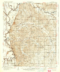
1935 Map of Crenshaw
USGS Topo · Published 1935About this map
Coldwater River snakes across this 1930s landscape, marking the complex drainage patterns and fertile lowlands of the Mississippi Delta edge and northern hill country. The survey illustrates a densely settled rural society before major mid-century agricultural shifts, defined by a network of small community centers like Arkabutla and Strayhorn. Transportation is anchored by the Yazoo and Mississippi Valley RR running north through Crenshaw and Prichard, mirroring the older water routes of Lake Cormorant Bayou and Big Bayou.
Find a feature on this map
74 named features on this map. Tap any name to fly to it.
Don’t see what you’re looking for? This feature index may not catch every label — zoom into the map to look around manually.
Map Details
Editions of this 1935 Crenshaw Map
2 editions found
Other maps of this area

1908 · Hollywood
USGS Topo · 1:24,000

1908 · Walnut Lake
USGS Topo · 1:24,000

1910 · Walnut Lake
USGS Topo · 1:31,680

1913 · Hollywood
USGS Topo · 1:31,680

1931 · Horseshoe Lake
USGS Topo · 1:62,500

1932 · Horn Lake
USGS Topo · 1:48,000

1932 · Sledge
USGS Topo · 1:48,000

1932 · Marks
USGS Topo · 1:48,000

1932 · Crenshaw
USGS Topo · 1:62,500

1935 · Marks
USGS Topo · 1:62,500