
1940 Map of Oxford
USGS Topo · Published 1956About this map
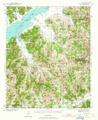
The University of Mississippi and the city of Oxford serve as the focal point of this 1940 survey, which captures the region during a period of significant hydrologic transformation. To the northwest, the Sardis Reservoir is shown with its normal pool and flood stage elevations defined, encroaching upon the bottomlands of the Tallahatchie River. This massive engineering project altered the landscape for established communities like Abbeville and Harmontown, while the Illinois Central railroad continued to anchor the local economy, passing through College Hill Sta and Taylor.
Find a feature on this map
65 named features on this map. Tap any name to fly to it.
Don’t see what you’re looking for? This feature index may not catch every label — zoom into the map to look around manually.
Map Details
Editions of this 1940 Oxford Map
2 editions found
Other maps of this area

1942 · Denmark
USGS Topo · 1:62,500

1943 · Denmark
USGS Topo · 1:62,500

1943 · Oxford
USGS Topo · 1:62,500

1944 · Senatobia
USGS Topo · 1:62,500

1944 · Tyro
USGS Topo · 1:62,500

1944 · Potts Camp
USGS Topo · 1:62,500

1945 · Potts Camp
USGS Topo · 1:62,500

1952 · Sardis
USGS Topo · 1:62,500

1953 · Sardis
USGS Topo · 1:62,500

1954 · Oakland
USGS Topo · 1:62,500