1940 Map of Oxford
USGS Topo · Published 1965About this map
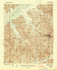
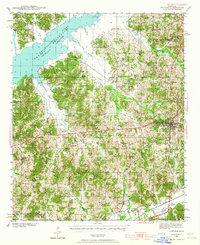
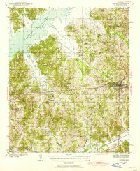
The University of Mississippi serves as the focal point of this North Mississippi landscape during a period of transition in the late 1930s. To the northwest, the newly completed Sardis Reservoir Tallahatchie River is shown at its normal pool and flood stages, a massive engineering project that fundamentally altered the drainage of Lafayette Co. This survey captures the rural infrastructure of the era in remarkable detail, from the Illinois Central RR corridor connecting Abbeville and Oxford to the numerous small-scale community landmarks such as College Hill Sta and St Johns Cem. The interior is dotted with one-room schoolhouses and country churches like Davidson Sch and Buford Chapel, many associated with family names and local topography like Thacker Mtn. The southern extent is defined by the winding course of the Yocona River, reflecting the region's agricultural roots before later water management projects reached these reaches.
Find a feature on this map
57 named features on this map. Tap any name to fly to it.
Don’t see what you’re looking for? This feature index may not catch every label — zoom into the map to look around manually.
Map Details
Editions of this 1940 Oxford Map
2 editions found
Historical Maps of Oxford Through Time
4 maps found