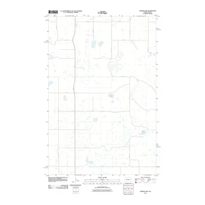
2011 Map of Senior Lake
USGS Topo · Published 2011About this map
Senior Lake and Rush Lake dot this corner of Kidder County, representing the characteristic prairie pothole region of North Dakota. The landscape is defined by a rigorous section-line road grid, including 28th Ave SE and 4th St SE, which reveals the late-twentieth and early-twenty-first-century agricultural organization of the Great Plains. This 2011 survey by the U.S. Geological Survey illustrates how the natural topography of scattered wetlands persists amidst the rectilinear human interventions of rural development. The sparse distribution of named features emphasizes the vast, open nature of this prairie environment, where transport routes like 10th St SE provide the primary framework for movement across the wetland-rich terrain.
Find a feature on this map
15 named features on this map. Tap any name to fly to it.
Don’t see what you’re looking for? This feature index may not catch every label — zoom into the map to look around manually.
Map Details
Editions of this 2011 Senior Lake Map
This is the sole edition of this map. No revisions or reprints were ever made.
Other maps of this area

1952 · New Rockford
USGS Topo · 1:250,000

1954 · McClusky
USGS Topo · 1:250,000

1956 · New Rockford
USGS Topo · 1:250,000

1958 · McClusky
USGS Topo · 1:250,000

1971 · New Rockford
USGS Topo · 1:250,000

1972 · Tuttle
USGS Topo · 1:24,000

1972 · Robinson
USGS Topo · 1:24,000
1978 · Goodrich East
USGS Topo · 1:24,000
1978 · Willow Lake
USGS Topo · 1:24,000
1978 · Senior Lake
USGS Topo · 1:24,000