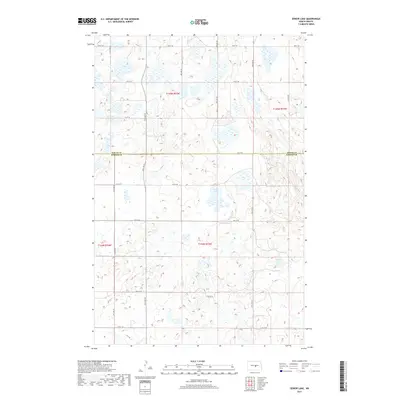
2017 Map of Senior Lake
USGS Topo · Published 2017About this map
Senior Lake and Rush Lake dominate the hydrography of this North Dakota prairie landscape, where the flat terrain is defined by a dense network of seasonal wetlands and small basins. Located along the boundary of Wells Co Kidder Co, the area is organized by a precise grid of section lines and gravel roads, including 3rd St SE and 24th Ave SE. The survey reflects the enduring Public Land Survey System (PLSS) structure of the Missouri Coteau region, shown here within t144n r73w and surrounding townships. This 2017 edition records the modern state of the northern plains, where the land is primarily divided into large-scale agricultural blocks. The distribution of water features suggests a dynamic ecosystem of prairie potholes, essential for regional hydrology and migratory bird habitats.
Find a feature on this map
24 named features on this map. Tap any name to fly to it.
Don’t see what you’re looking for? This feature index may not catch every label — zoom into the map to look around manually.
Map Details
Editions of this 2017 Senior Lake Map
This is the sole edition of this map. No revisions or reprints were ever made.
Other maps of this area

1952 · New Rockford
USGS Topo · 1:250,000

1954 · McClusky
USGS Topo · 1:250,000

1956 · New Rockford
USGS Topo · 1:250,000

1958 · McClusky
USGS Topo · 1:250,000

1971 · New Rockford
USGS Topo · 1:250,000

1972 · Tuttle
USGS Topo · 1:24,000

1972 · Robinson
USGS Topo · 1:24,000
1978 · Goodrich East
USGS Topo · 1:24,000
1978 · Willow Lake
USGS Topo · 1:24,000
1978 · Senior Lake
USGS Topo · 1:24,000