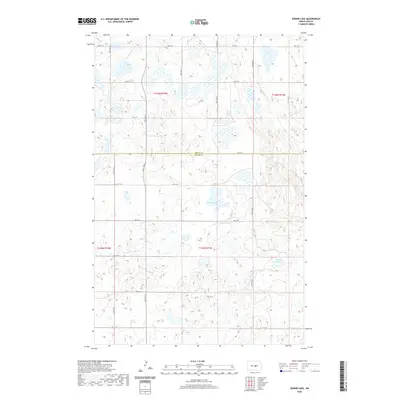
2020 Map of Senior Lake
USGS Topo · Published 2020About this map
Senior Lake and Rush Lake dominate this prairie landscape along the border of Wells Co and Kidder Co. The terrain is characterized by a high density of small wetlands and depressions typical of the Missouri Coteau region, with water bodies varying from permanent lakes to seasonal basins. A rigid grid of township roads, including north-south routes like 24th Ave SE and east-west roads such as 6th Ave SE, provides access to this rural agricultural and grazing land. The lack of concentrated settlements or named townsites highlights the sparse population of this area during the twenty-first century, as the landscape remains primarily defined by its natural topography and the rectilinear patterns of the Public Land Survey System.
Find a feature on this map
24 named features on this map. Tap any name to fly to it.
Don’t see what you’re looking for? This feature index may not catch every label — zoom into the map to look around manually.
Map Details
Editions of this 2020 Senior Lake Map
This is the sole edition of this map. No revisions or reprints were ever made.
Other maps of this area

1952 · New Rockford
USGS Topo · 1:250,000

1954 · McClusky
USGS Topo · 1:250,000

1956 · New Rockford
USGS Topo · 1:250,000

1958 · McClusky
USGS Topo · 1:250,000

1971 · New Rockford
USGS Topo · 1:250,000

1972 · Tuttle
USGS Topo · 1:24,000

1972 · Robinson
USGS Topo · 1:24,000
1978 · Goodrich East
USGS Topo · 1:24,000
1978 · Willow Lake
USGS Topo · 1:24,000
1978 · Senior Lake
USGS Topo · 1:24,000