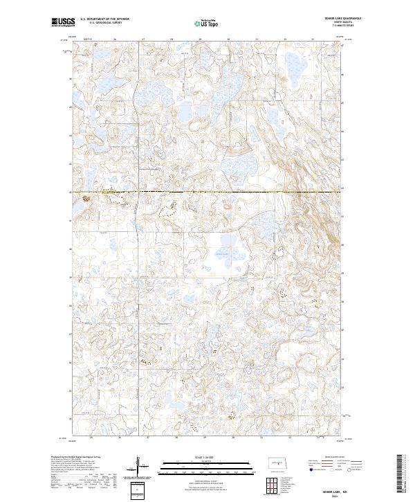
2024 Map of Senior Lake
USGS Topo · Published 2024About this map
The Wells County Waterfowl Production Area straddles the boundary between Wells Co and Kidder Co, marking a landscape of significant ecological preservation in central North Dakota. This prairie pothole region is characterized by an intricate network of small wetlands and larger water bodies like Senior Lake and Rush Lake, which define the local drainage patterns. The terrain is organized by a strict section-line road grid, including 3rd St SE through 11th St SE, which reflects the enduring influence of the Public Land Survey System on the rural North Dakota landscape. The map provides a detailed view of these natural depressions and elevations within townships t145n r73w and t144n r73w, illustrating how the hydrology of the plains dictates the placement of transit corridors and conservation boundaries.
Find a feature on this map
17 named features on this map. Tap any name to fly to it.
Don’t see what you’re looking for? This feature index may not catch every label — zoom into the map to look around manually.
Map Details
Editions of this 2024 Senior Lake Map
This is the sole edition of this map. No revisions or reprints were ever made.
Other maps of this area

1952 · New Rockford
USGS Topo · 1:250,000

1954 · McClusky
USGS Topo · 1:250,000

1956 · New Rockford
USGS Topo · 1:250,000

1958 · McClusky
USGS Topo · 1:250,000

1971 · New Rockford
USGS Topo · 1:250,000

1972 · Tuttle
USGS Topo · 1:24,000

1972 · Robinson
USGS Topo · 1:24,000
1978 · Goodrich East
USGS Topo · 1:24,000
1978 · Willow Lake
USGS Topo · 1:24,000
1978 · Senior Lake
USGS Topo · 1:24,000