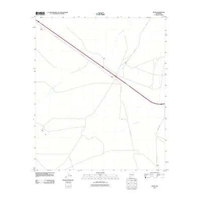
2010 Map of Separ
USGS Topo · Published 2010About this map
Separ serves as the focal point of this southwestern New Mexico landscape, situated at a junction where local ranching routes meet the arterial path of the Frontage Rd and the interstate. The map illustrates a high-desert environment defined by intermittent water sources and established family holdings, including Separ Ranch, Cox Ranch, and Moore Ranch. These named ranching sites, coupled with features like Glaze Windmill, highlight the necessity of water management in a region where Ninetysix Creek and Burro Cienaga provide the primary drainage. The network of local thoroughfares such as Warren Ranch Rd and Moore Ranch Rd reveals the persistent connectivity between these remote outposts. Rising above the flatlands, Pigeon Hill provides a distinct topographic landmark amidst the desert floor, anchoring the southwestern portion of the survey.
Find a feature on this map
13 named features on this map. Tap any name to fly to it.
Don’t see what you’re looking for? This feature index may not catch every label — zoom into the map to look around manually.
Map Details
Editions of this 2010 Separ Map
This is the sole edition of this map. No revisions or reprints were ever made.
Other maps of this area

1954 · Silver City
USGS Topo · 1:250,000

1958 · Silver City
USGS Topo · 1:250,000

1962 · Silver City
USGS Topo · 1:250,000

1962 · Ninetysix Ranch
USGS Topo · 1:24,000

1962 · Lisbon
USGS Topo · 1:24,000

1963 · Soldiers Farewell Hill
USGS Topo · 1:24,000

1964 · Muir Ranch
USGS Topo · 1:24,000
1964 · The Saltys
USGS Topo · 1:24,000
1964 · Separ NE
USGS Topo · 1:24,000
1964 · Separ
USGS Topo · 1:24,000