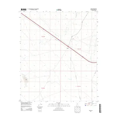
2013 Map of Separ
USGS Topo · Published 2013About this map
Separ serves as the central point of this high-desert corridor in Grant County, where the infrastructure of modern transit overlays a landscape defined by seasonal watercourses and rangeland. The settlement is situated at a critical junction of transportation, flanked by Frontage Rd and a major diagonal thoroughfare. The surrounding terrain is marked by the intermittent flow of Ninetysix Cr and Burro Cienaga, features that historically dictated the placement of ranches and travel routes in this arid environment. To the southwest, the Pigeon Hills provide the primary topographic relief in an otherwise expansive basin. The network of local roads, including Warren Ranch Rd and Moore Ranch Rd, highlights the enduring pastoral nature of the region, connecting isolated ranching outposts to the primary transit spine that cuts through the quadrangle.
Find a feature on this map
13 named features on this map. Tap any name to fly to it.
Don’t see what you’re looking for? This feature index may not catch every label — zoom into the map to look around manually.
Map Details
Editions of this 2013 Separ Map
This is the sole edition of this map. No revisions or reprints were ever made.
Other maps of this area

1954 · Silver City
USGS Topo · 1:250,000

1958 · Silver City
USGS Topo · 1:250,000

1962 · Silver City
USGS Topo · 1:250,000

1962 · Ninetysix Ranch
USGS Topo · 1:24,000

1962 · Lisbon
USGS Topo · 1:24,000

1963 · Soldiers Farewell Hill
USGS Topo · 1:24,000

1964 · Muir Ranch
USGS Topo · 1:24,000
1964 · The Saltys
USGS Topo · 1:24,000
1964 · Separ NE
USGS Topo · 1:24,000
1964 · Separ
USGS Topo · 1:24,000