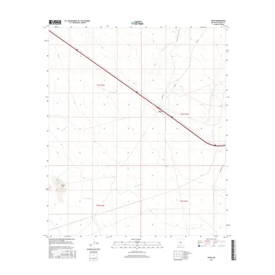
2017 Map of Separ
USGS Topo · Published 2017About this map
Separ sits as a lonely desert crossroads in southwestern New Mexico, defined by the long diagonal transit corridor crossing the high Chihuahuan Desert. This 2017 survey illustrates the enduring importance of this remote transit point, where modern infrastructure follows the historic path through the arid basin. The landscape is marked by ephemeral drainage systems including Ninetysix Cr and the broad, winding path of Burro Cienaga. These features highlight the traditional reliance on seasonal water sources in a region where the topography is largely defined by gentle slopes and intermittent desert washes. The map serves as a contemporary record of a settlement that has long functioned as a vital link for travelers and freight moving between the continental interior and the far west.
Find a feature on this map
3 named features on this map. Tap any name to fly to it.
Don’t see what you’re looking for? This feature index may not catch every label — zoom into the map to look around manually.
Map Details
Editions of this 2017 Separ Map
This is the sole edition of this map. No revisions or reprints were ever made.
Other maps of this area

1954 · Silver City
USGS Topo · 1:250,000

1958 · Silver City
USGS Topo · 1:250,000

1962 · Silver City
USGS Topo · 1:250,000

1962 · Ninetysix Ranch
USGS Topo · 1:24,000

1962 · Lisbon
USGS Topo · 1:24,000

1963 · Soldiers Farewell Hill
USGS Topo · 1:24,000

1964 · Muir Ranch
USGS Topo · 1:24,000
1964 · The Saltys
USGS Topo · 1:24,000
1964 · Separ NE
USGS Topo · 1:24,000
1964 · Separ
USGS Topo · 1:24,000