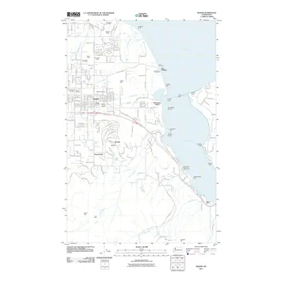
2011 Map of Sequim
USGS Topo · Published 2011About this map
Sequim sits at the heart of this coastal landscape, situated on the Sequim Prairie where the Olympic Peninsula meets the Strait of Juan de Fuca. The map details a complex shoreline defined by landforms like Gibson Spit, Travis Spit, and Kiapot Point, which shelter the waters of Washington Harbor and Sequim Bay. This coastal geography supported diverse developments, from the recreation-focused John Wayne Marina and Sequim Bay State Park Campground to established sites like Port Williams.
Find a feature on this map
44 named features on this map. Tap any name to fly to it.
Don’t see what you’re looking for? This feature index may not catch every label — zoom into the map to look around manually.
Map Details
Editions of this 2011 Sequim Map
This is the sole edition of this map. No revisions or reprints were ever made.
Other maps of this area

1938 · Mt Constance
USGS Topo · 1:125,000

1938 · Dungeness
USGS Topo · 1:62,500

1939 · Port Townsend
USGS Topo · 1:62,500

1939 · Dungeness
USGS Topo · 1:62,500

1940 · Quilcene
USGS Topo · 1:62,500

1946 · Tyler Peak
USGS Topo · 1:62,500

1948 · Tyler Peak
USGS Topo · 1:62,500
1953 · Uncas
USGS Topo · 1:24,000
1953 · Gardiner
USGS Topo · 1:24,000

1956 · Sequim
USGS Topo · 1:24,000